This article is about the relevant content of UAV route planning problem, including the uniqueness of UAV path planning problem, problem definition, path planning type, solution algorithm, etc.

01 The uniqueness of UAV path planning problem
With the rapid development of unmanned aerial vehicle (UAV) technology, its application scope continues to expand. From military reconnaissance, environmental monitoring to commercial distribution, UAV is playing an increasingly important role in various fields. However, as application scenarios become more complex and mission requirements increase, unmanned autonomous navigation capabilities have become a key factor restricting the further development of unmanned aerial vehicles. As a core component of autonomous navigation, path planning is increasingly important. Compared with traditional ground robot path planning, UAV path planning faces unique challenges.
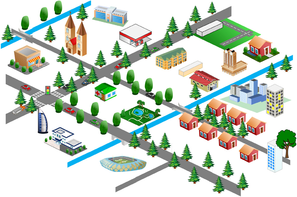
First, UAVs move in three-dimensional space. As shown in the figure, UAVs can change heights, which increases the degree of freedom and makes the planning problem more complex than traditional two-dimensional ground robots. This extra dimension not only expands the range of possible tasks, but also requires algorithms that can effectively handle the energy consumption and airflow effects of altitude changes.
Secondly, some UAVs (such as fixed-wing) cannot hover like multi-rotor aircraft due to their aerodynamic characteristics and need to maintain a constant cruising speed. This speed constraint brings additional complexity to path planning, as the algorithm needs to consider factors such as turning radius and climb rate to ensure that the generated path conforms to the physical limitations of the aircraft.
These characteristics make UAV path planning face unique challenges in algorithm design and implementation.
02 Problem Definition
UAV path planning is essentially a complex optimization problem whose goal is to generate a safe and efficient path from the initial location to the destination under specific constraints. Mathematically, this problem can be formally expressed as follows: For a three-dimensional (D3) Path planning problem with static obstacles in the environment, assuming O={O1, O2, ..., On}⊂D3Represents a set of obstacles, and the path needs to start from the starting point Psto end point Pt. Assume that the gap space without obstacles is represented by Wfree,Then the path planning problem in the three-dimensional environment (Ps, Pt, Wfree) can define the following function: δ(0)=PsRepresents the initial moment, δ(T)=PtRepresents the target time, for all β∈[0, T], there exists φ=δ(β)∈Wfree, where φ is called the path planning of unmanned aerial vehicles (UAVs). This mathematical model not only needs to consider space constraints, but also factors such as the UAV's dynamic characteristics, energy constraints, and mission requirements. The goal of the path planning algorithm is to find an optimal or approximately optimal path under these complex constraints to meet specific performance indicators, such as the shortest distance, minimum energy consumption, maximum security, etc.
03 Path planning type
Based on application scenarios and mission requirements, UAV path planning can be divided into several main types, each type has its specific goals and challenges.
Information Path Planning (IPP)Designed to maximize the utility of data collection, which is particularly important in tasks such as environmental monitoring and disaster assessment. The IPP algorithm needs to optimize the UAV's path to obtain the most valuable information under the constraints of limited resources (such as flight time, energy).
Coverage Path Planning (CPP)The goal is to determine a path that passes through all areas of interest while avoiding obstacles. This kind of planning is widely used in agricultural monitoring, search and rescue and other scenarios, requiring the algorithm to effectively balance coverage integrity and path efficiency.
Collaborative path planningInvolving the collaborative work of multiple UAVs, a coordinated task path needs to be generated for each UAV. This kind of planning must not only consider the constraints of a single UAV, but also deal with complex issues such as communication, task allocation, and conflict avoidance between UAVs.
reactive path planningIt emphasizes the real-time adjustment capability of the path to cope with dynamically changing environments or emergencies. This planning method requires algorithms to have fast response and decision-making capabilities that can maintain mission continuity while ensuring safety.
04 Solving algorithm
Methods for solving UAV path planning problems can be roughly divided into three categories: classical methods, soft computing methods and hybrid methods. Each method has its own characteristics and applicable scenarios. We will introduce these methods in detail below.
1·Classic method
Environment representation method:Mainly include roadmap method and unit decomposition method. The roadmap method reduces the free space to a one-dimensional line segment network. Common ones include Voronoi diagram and visibility diagram. The Voronoi diagram divides the space by constructing equidistant lines and is suitable for generating maximum gap paths; the visibility diagram connects all mutually visible vertices and is suitable for finding the shortest path. The unit decomposition method decomposes the barrier-free space into non-overlapping convex polygons and then constructs a connectivity graph. This approach can effectively handle complex environments but may face computational challenges in high-dimensional spaces. These environment representation methods lay the foundation for subsequent path search, which can significantly reduce the search space and improve algorithm efficiency.
Search algorithm:It is a core component of classical methods, including mathematical programming methods, graph search methods, potential field methods and sampling-based methods. Mathematical programming methods use mathematical models and probabilistic predictions, such as linear programming and dynamic programming, and are suitable for problems with clear mathematical models. Among the graph search methods, Dijkstra's algorithm is based on dynamic programming and uses a single heuristic method, while the A* algorithm is an improved version of Dijkstra, which combines best-first search and can find the optimal path faster in many cases. Depth-first search (DFS) and breadth-first search (BFS) are also commonly used graph search strategies, which are suitable for depth exploration and breadth exploration respectively. The potential field method constructs a virtual force field to guide the movement of the drone by assigning repulsive forces to obstacles and attractive forces to targets. This method is simple to calculate and suitable for real-time applications, but may fall into local minima. Sampling-based methods such as Probabilistic Roadmap (PRM) and Rapidly Exploring Random Trees (RRT) randomly sample or rapidly expand in the configuration space and are suitable for path planning in high-dimensional space, but may be difficult to guarantee optimality. Each of these search algorithms has its own characteristics, and it is necessary to choose the appropriate algorithm according to the specific problem.
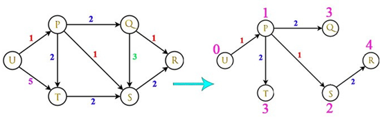
Dijkstra algorithm diagram
2·Soft computing methods
Soft computing methods simulate the reasoning and adaptability of the human brain and are suitable for dealing with complex and uncertain problems. This type of method is usually highly adaptive and robust, and can perform well in incomplete information or dynamic environments.
Machine learning methods:Including supervised learning, unsupervised learning, reinforcement learning and deep learning, it is widely used in tasks such as path planning and collision avoidance. Supervised learning can be used to predict optimal paths, unsupervised learning can help identify environmental features, reinforcement learning can learn optimal strategies by interacting with the environment, and deep learning can process high-dimensional input data such as images or point cloud data. The advantage of these methods is that they can learn from large amounts of data and continuously improve performance with the accumulation of experience. For example, deep reinforcement learning algorithms such as Deep Q-Network (DQN) have been successfully applied to UAV navigation tasks in complex environments. An important advantage of machine learning methods is their ability to generalize to new, unseen situations.
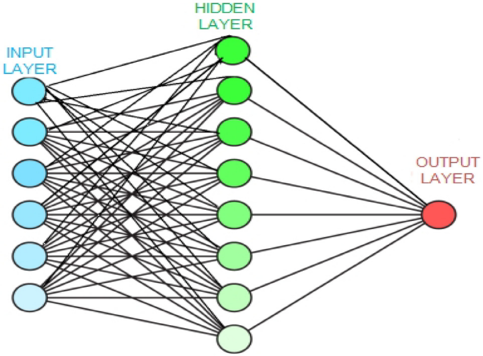
Schematic diagram of artificial neural network
Fuzzy inference system:Use "if-then" rules to deal with uncertainty, especially for obstacle avoidance problems. This method can handle fuzzy and imprecise information and simulate the decision-making process of human experts. In UAV path planning, fuzzy logic can be used to handle uncertainty in sensor data, evaluate the safety and efficiency of paths, and make real-time decisions in complex environments. A major advantage of fuzzy systems is their interpretability, where the decision-making process can be expressed in human-understandable language rules. However, designing effective fuzzy rules and member functions may require considerable expertise and debugging efforts.
Metaheuristics:It is a type of optimization algorithm inspired by natural phenomena, including simulated annealing (SA), genetic algorithm (GA), ant colony optimization (ACO), particle swarm optimization (PSO), and differential evolution (DE). The simulated annealing algorithm simulates the metal cooling process and avoids falling into a local optimum by allowing a certain probability of "uphill" movement during the search process. The genetic algorithm is based on the natural selection mechanism and optimizes the solution population by simulating the evolutionary process, and is suitable for complex multi-objective optimization problems. The ant colony optimization algorithm simulates the behavior of ant groups and searches for the shortest path through the pheromone mechanism, which is particularly suitable for solving discrete optimization problems. The particle swarm optimization algorithm simulates the behavior of a flock of birds or a school of fish and optimizes global and local solutions through information sharing among individuals. It is highly computationally efficient and easy to implement. The differential evolution algorithm is similar to the genetic algorithm, but has better convergence and simplicity of implementation, and is suitable for optimization problems in continuous spaces. These metaheuristic methods perform well in UAV path planning and can effectively handle multi-objective, high-dimensional complex optimization problems, but may require parameter tuning for specific problems to obtain optimal performance.
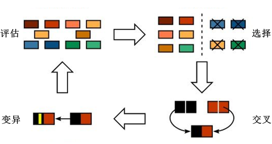
Schematic diagram of genetic algorithm
3 · Mixed methods
Hybrid methods combine the advantages of different techniques to overcome the limitations of a single method and show strong performance in complex UAV path planning problems.
Common combinations include combinations of different soft computing methods, e.g.The combination of gray wolf optimization algorithm and reinforcement learning, which can improve local optimization efficiency while maintaining global search capabilities;Combination of classical methods and soft computing technology, such as the mixture of artificial potential field method and RRT-Connect algorithm, which can improve the global optimality of the path while ensuring fast response;Combination of classical methods and soft computing methods, such as the combination of RRT and gray wolf optimization algorithm, can further optimize on the basis of quickly generating feasible paths.
Although hybrid methods may increase algorithm complexity, they are generally able to provide better performance and higher robustness in a variety of challenging UAV path planning scenarios.
Conclusion
This article reviews classic methods, soft computing methods and hybrid methods in the field of UAV path planning, which have played an important role in promoting the development of UAV autonomous navigation technology. However, the increasing complexity of application scenarios has brought challenges such as dynamic environment adaptation, multi-UAV collaboration and difficult tasks. These challenges are driving algorithm optimization and technological innovation. Looking to the future, the integration of advanced technologies such as deep learning with traditional methods is expected to open up new research avenues for drone applications. UAV path planning has transcended a single technical field and developed into an interdisciplinary research hotspot. Progress in this field is bringing technological innovation to applications such as environmental monitoring and disaster relief, and providing innovative solutions to complex social problems.
References
[1] Quan L, Han L, Zhou B, et al. Survey of UAV motion planning[J]. IET Cyber‐systems and Robotics, 2020, 2(1): 14-21.
[2] Aggarwal S, Kumar N. Path planning techniques for unmanned aerial vehicles: A review, solutions, and challenges[J]. Computer communications, 2020, 149: 270-299.
[3] Ghambari S, Golabi M, Jourdan L, et al. UAV path planning techniques: a survey[J]. RAIRO-Operations Research, 2024, 58(4): 2951-2989.

Machine-translated from the Chinese original 无人机航线规划问题 (published 2024-10-21). WeChat original ↗